
The UPC’s NanoSat Lab demonstrates the feasibility of using nanosatellites to observe the Earth and monitor climate change
Maps of Arctic sea ice concentration from 13 to 15 November: (a) map with FMLP-2 microwave radiometer data, (b) ground truth map (i.e. on-site measurements) and (c) error map
Why are these data important
Obtaining data and understanding the behaviour of soil moisture and sea ice extent and thickness is essential to understand the water cycle, since the behaviour of ocean water, clouds and ice determines the planet’s climate and causes several atmospheric phenomena. The movement of water masses, or thermohaline circulation, transports energy in the form of heat and mass in the form of dissolved solids and gases around the globe, reducing differences. This circulation makes the heat go from the warmest to the coldest areas and vice versa; it acts as a giant radiator.
Several elements are involved in this process, such as temperature, salinity and soil moisture, which are related to atmospheric phenomena like El Niño, major floods or droughts. These phenomena influence both populations and several economic sectors in many different ways: affecting crops or creating possibilities of new sea routes through the Arctic.
Scientific papers on the results
- The Flexible Microwave Payload-2: An SDR-Based GNSS-Reflectometer and L-Band Radiometer for CubeSats
- Snow and Ice Thickness Retrievals Using GNSS-R: Preliminary Results of the MOSAiC Experiment
- Sea Ice Thickness Estimation Based on Regression Neural Networks Using L-Band Microwave Radiometry Data from the FSSCat Mission
- Sea Ice Concentration and Sea Ice Extent Mapping with L-Band Microwave Radiometry and GNSS-R Data from the FSSCat Mission Using Neural Networks
- Soil Moisture Estimation Synergy Using GNSS-R and L-Band Microwave Radiometry Data from FSSCat/FMPL-2
- Towards Federated Satellite Systems and Internet of Satellites: The Federation Deployment Control Protocol
- Demonstration of the Federated Satellite Systems Concept for Future Earth Observation Satellite Missions
- A Novel Dissemination Protocol to Deploy Opportunistic Services in Federated Satellite Systems
- Proof-of-Concept of a Federated Satellite System Between Two 6-Unit CubeSats for Distributed Earth Observation Satellite Systems
- The Flexible Microwave Payload-2: Design, Implementation, and Optimization of a GNSS-R and Radiometry Processor for CubeSat-Based Earth Observation Missions
- Demonstration of the Federated Satellite Systems Concept for Future Earth Observation Satellite Missions
- FSSCat, the 2017 Copernicus Masters “ESA Sentinel Small Satellite Challenge” Winner: A Federated Polar and Soil Moisture Tandem Mission Based on 6U CubeSats
The FSSCat is ESA’s first mission that relies on CubeSats to support the Copernicus monitoring services for land and marine environment of the European Earth Observation programme. The mission won the Sentinel Small Satellite (S^3) Challenge Award of ESA and was honoured as the Copernicus Masters Overall Winner in 2017.
Sep 20, 2021
On 3 September 2020, the European Space Agency (ESA) launched the FSSCat mission into space. Students and young researchers at the NanoSat Lab of the Universitat Politècnica de Catalunya · BarcelonaTech (UPC) have used proprietary technology onboard two 6-unit CubeSat-type nanosatellites to generate the first maps of soil moisture; sea ice concentration, extent and thickness; and Arctic salinity. The shoebox-sized nanosatellites, called ³Cat-5/A and ³Cat-5/B, have provided the data to the Copernicus services for land and marine environment of the European Earth Observation programme.
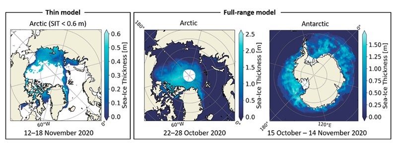
Maps of Arctic and Antartic sea ice concentration
According to Copernicus policy, the data are open and available from the European platform NextGEOSS, which is a federated data hub for access and exploitation of Earth observation data.
Academic research
The mission has been successfully conducted from UPC facilities. First, the NanoSat Lab, a laboratory for the design and manufacture of payloads and small satellites. It is located on the UPC’s North Diagonal Campus and linked to the Barcelona School of Telecommunications Engineering (ETSETB), the CommSensLab-UPC research centre and the Department of Signal Theory. Second, the Montsec satellite ground station (SGSMontsec), in Lleida, which has been receiving the scientific data from the mission. The station was developed ad hoc by the NanoSat Lab and is managed jointly with the Institute of Space Studies of Catalonia (IEEC).
UPC doctoral degree holders Joan Francesc Muñoz and Joan Adrià Ruiz de Azúa have developed the microwave payloads and the SGSMontsec together with doctoral students Lara Fernandez and Adrián Pérez, from the UPC’s Department of Signal Theory and Communications.
Additionally, doctoral students David Llaveria and Christoph Herbert, and doctoral degree holder Miriam Pablos, who is currently working at the Institute of Marine Sciences of the Spanish National Research Council (CSIC), have actively collaborated in the processing of data. The group has been led by professor and NanoSat Lab director Adriano Camps.
The main objective of the mission was to monitor polar ice and soil moisture while testing intersatellite communication systems in order to create a future network of federated satellites. Such satellites are devised to share on-board sensors, loads and systems to perform certain operations, like downloading data, collaboratively. The satellites of the mission have used optical and radio links to test advanced concepts of federated satellites and other ground sensors.
Miniature technology for Earth observation
The students and young doctoral degree holders at the NanoSat Lab designed two payloads that have travelled aboard the 3Cat-5/A and acted as a dual microwave system (FMPL-2), by combining an L-band microwave radiometer to detect and mitigate radio frequency interference and a global navigation satellite system reflectometer (GNSS-R) using GPS and Galileo signals.
The GNSS reflectometer has acted as a radar, but without sending any signals, just receiving direct signals from other navigation satellites, such as signals reflected from the Earth’s surface. In addition to providing altimetry data, the time delay that occurred in receiving this type of signal has allowed to obtain information about the reflecting surface, such as ice or water.
This dual microwave system (FMPL-2), which weighs only 1 kg and fits inside a module of less than 1 L in volume, has provided Earth observation data with a spatial resolution of about 600 m at 500 km height with the GNSS-R and about 350 x 500 km with the L-band radiometer.
The data from the L-band microwave radiometer have been processed similarly to those of ESA’s SMOS mission, launched in 2009 in collaboration with the Institute of Marine Sciences.
While the SMOS mission data are used to provide disaggregated moisture maps at 1 km resolution by merging with visible spectrum and near infrared data, the FSSCat, although based on a much poorer native resolution, provides disaggregated products at 36 km.

Top image: animation of one of the maps showing the soil moisture evolution, also in non-frozen areas, from October 1 to December 4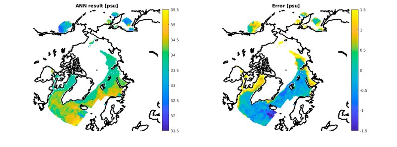
Map of Arctic salinity measured from 1 to 15 October 2020
In fact, the ³Cat-5/A and ³Cat-5/B nanosatellites have provided data on essential climate variables to monitor with highly accurate spatial and temporal resolutions at a fraction of the costs associated with conventional satellites. The data confirm, for example, that the year 2020’s minimum Arctic ice extent was the second lowest in the satellite record.
Funded and supervised by ESA, the final FSSCat mission has been carried out by a consortium that is made up of the UPC’s NanoSat Lab, DEIMOS Engenharia (the Portuguese branch of the Elecnor Deimos group), Golbriak Space OÜ (Estonia), Cosine Remote Sensing (the Netherlands) and Tyvak International (Italy), which was responsible for testing the platforms, integrating components and performing operations during the mission.
The ɸ-sat-1 technology demonstrator was also on board, it is ESA’s first artificial intelligence in space and it has filtered out images of the Earth that were not suitable for use because of cloud cover.
A key player in the NewSpace Strategy for Catalonia
The NanoSat Lab has previously developed other small satellites of the 3Cat family, such as the 3Cat-2, the first Catalan satellite to be placed in orbit, in August 2016.
In this laboratory, doctoral students are working on how to apply artificial intelligence to engineering systems designed for future space missions, such as merging SMOS and Sentinel-1 data, mitigating radio frequency interference and providing intersatellite contact to set up connections and federations, among others.
Its experience and results have turned the laboratory into a key player in the NewSpace Strategy for Catalonia. Driven by the Catalan government, NewSpace aims to use CubeSats to develop a new market and a new Catalan technological sector that has a binding effect on other technologies, such as 3D printing, artificial intelligence, advanced electronics for sensors and computers and next-generation mobile communications (IoT and 5G).

More information
Related news
- Introducing the Newest ESA Third Party Missions ('Earth online' de l'ESA, 22/12/2020)
- Two UPC nanosatellites in orbit to study polar regions and provide Earth observation images by using artificial intelligence (03/09/2020)